

Palmer's Cow-trail represents a little-known route used to bring cattle back and forth across Penticton Cr., providing a connection between the Carmi Highlands to the east of Penticton Cr., and Campbell Mt. on the west.
It might be envisioned as an entry-component of a larger network of vague wildlife and cow-trails on the east side of Penticton Creek. Note however, that the creek is only crossable during low-water - usually at the end of Nov., early Dec., and even then, is strewn with dangerous, slippery rocks of all shape and size. Consider yourself warned! Finding yourself in a situation where you need to be rescued as you flow down the creek from here would be very challenging for Search & Rescue!
These Lower Carmi trails make their way up, down and across the west face of the Lower Carmi area on steep, loose surface material.
This chapter examines a short dual-track trail which descends to Penticton Creek and presently ends - because the current depth of Penticton Cr. The trail is part of the Sather Ranch (Palmer Sather) cattle-driving route.
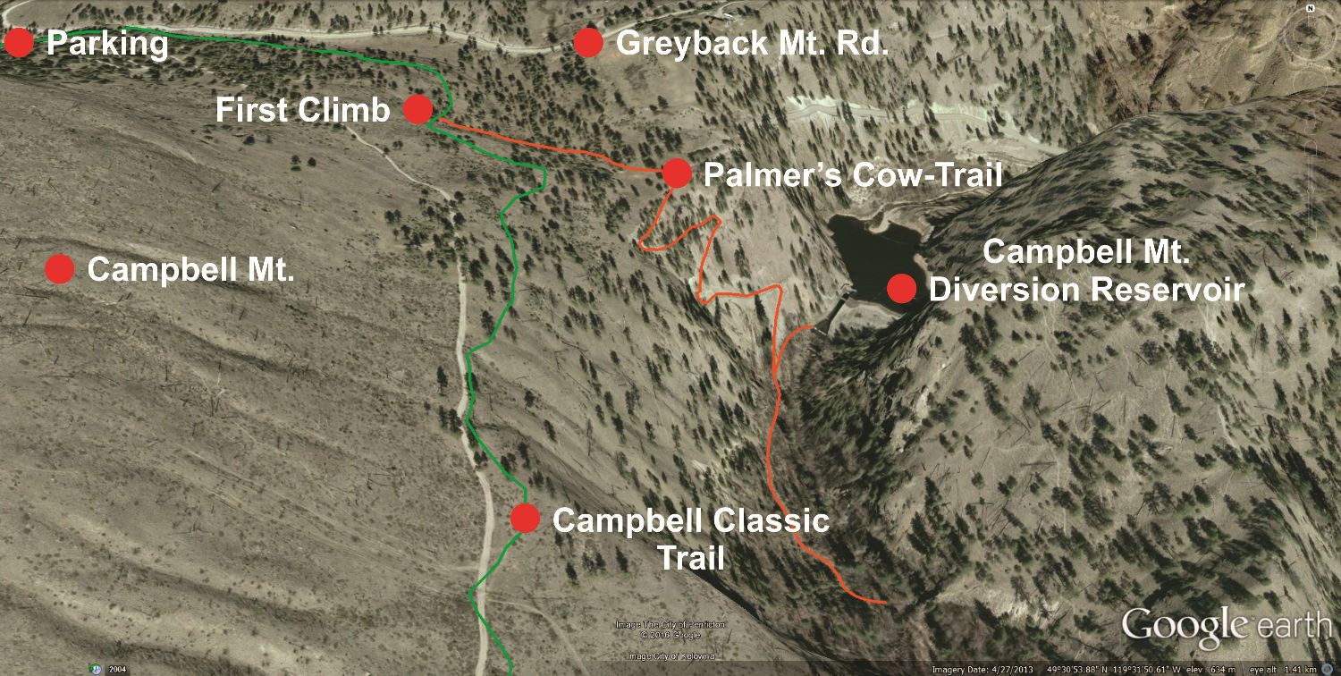
Start your exploration of Palmer's Cow-trail by driving to Campbell Mt's upper parking area, located approximately 2.2Km up Greyback Mt. Rd. - measured from the intersection of Greyback Mt. Rd. and Naramata Rd.
From the upper Campbell Mt. parking area (aka; "The Yellow Gate"), head due east along the existing, well-delineated 'Campbell Classic' singletrack trail that the Trail Alliance and friends built several years ago. The trail soon wraps around the mountain and begins heading south.
500 meters along, at the first major hill-climb, you'll notice a two-track trail which continues east (left) across a plateau, take this side-trail instead of ascending the steep pitch on the singletrack.
Following this trail as it morphs between single and dual-track for 250 meters, you will come upon a large, blue 'Campbell Mt. Diversion Reservoir' sign and fenced-in area. Stay right of this fence. Some 20 meters along you will find an old, narrow two-track road descending south through an open wooden gate into Penticton Creek / canyon; this is Palmer's Cow-trail.
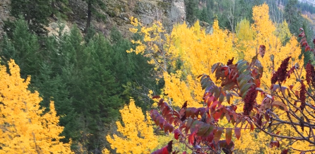
This steep, rocky two-track path switch-backs down for approximately 750 meters before reaching the creek. Enroute you will pass a mix of (currently colorful) coniferous and deciduous forest, along with equally flamboyant Oregon grape and sumac.
Once you've enjoyed the creek and head back up, you will no doubt notice a wooden man-gate which has been constructed on the right-hand side. This will allow you to see the lower reaches of the reservoir. Please do not proceed all the way to the main / upper dam, as this is a restricted area. Despite the fact that all of the 'no entry' signs have long-since been vandalized and removed, the actual dam is off-limits to the public due to numerous falling hazards.
If caught in the area immediately adjacent to the dam, there is a likelihood that you will be prosecuted, and this area will be closed to the public altogether. Please don't ruin the opportunity of this trail experience for everyone else by being a Curious George.
In a nutshell; this short, steep trail is a beginner to intermediate hike and an [advanced] horseback outing, but due to the steep pitches, loose rocks and rough trail surface, mountain bikers need not apply. Sections east of the creek are not described herein, as they are difficult to access, wildly steep and I'm not keen on being blamed for folks drowning while trying to cross Penticton Cr., or injuring themselves once on the steep banks beyond.
Palmer's trail brings one into a secluded area of Penticton which has a particular charm all it's own. I've been coming here for years and am happy to share it with all of you, but please use common sense, be careful and don't trespass near the main dam.
If this description is not enough to make you comfortable with exploring this trail, please download and view the Google Earth data-file which shows the area in detail (you will of course, require a copy of Google Earth installed on your PC in order to view the file). You can also examine this image file, which shows a Google Earth screenshot / overview of the area in question.
Final note; I've not seen it myself, but stories exist of game-snares set in the lower zones, near the creek. If you bring pets down here, keep a sharp eye on them or keep them on-leash - just in case.
Vertical: 257m. | Length: 3 Km. Return | Water: Not potable | Cell: Higher Up