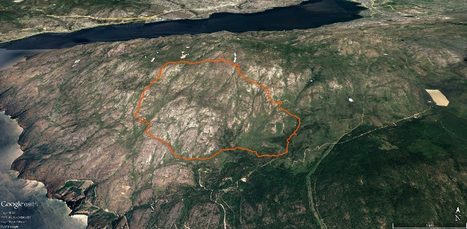
Click on image above for a larger overview.
Okanagan Mountain Provincial Park is located across Okanagan Lake opposite Peachland, south of Kelowna and north of Naramata - at the point where Okanagan Lake features a sharp bend.
The park is one of the largest in the area, covering 110.38 square kilometers. Most of the park is only accessible by foot, horseback, bicycle or boat, as motor vehicle access is restricted to BC Parks staff and technicians servicing the three telecommunications towers in the park.
The park comprises several trails, campsites (including six marine camp areas), lakes, and large areas of wilderness. Popular activities include hiking, camping, boating, mountain biking, and hunting (which, somewhat surprisingly, is permitted within BC Parks).
The rugged rocky terrain is habitat to a surprisingly wide array of wildlife, including mountain goats, white-tailed deer, moose, elk, lynx, marten, coyote and cougars. Small species include the Western harvest mouse, Nuttall’s cottontail, Spotted bat, Northern alligator lizard and Western skink.
A lightning-sparked wildfire in 2003 spread quickly, eventually burning most of the park. Burned-standing trees and other fire-related hazards still exist in the park, as such, please use caution if you are caught in the park during a windstorm.
Numerous access routes into Okanagan Mountain Park exist. The most popular for Kelowna residents is via Lakeshore Rd., while southerners generally employ a route accessible through a small BC Parks day-use area. This access point is the route that I’ll highlight in this chapter, as it’s the one that I used when I explored the area.
The parking lot is located near the end of a small service road, 4.7km up Chute Lake Rd. measured from the point at which one turns right onto Chute Lk. Rd., off North Naramata Rd. Follow this deeply potholed access road for a distance of 1.5km, where it ends in a small parking area with washrooms, picnic tables and a large information kiosk. Do not leave valuables in the cab of your vehicle!
Head over the footbridge and decide if you wish to travel right; to the summit of the mountain and a pair of small lakes; a hike-only route - or left, along the WildHorse trail, which takes one to many places, including the mountain summit or Kelowna (!). We'll be riding the WildHorse route between Naramata and Kelowna in Sept., and will update the Okanagan Mountain Park link on SweetSingletrack.ca thereafter.
On the looping adventure that I’ll highlight in this chapter, we headed right, up a combination of the Mountain Goat and Baker Lake trails. This found us at the summit of Okanagan Mountain Park, passing through numerous ecological environments along the way.
Near the summit, you will encounter a quality road (aka; the Divide Lake trail / radio tower service road). Head left, and in short order you’ll be standing on the summit of Okanagan Mt. Park, elevation 1571 meters.
Head back down the road, and you will soon see the Frederick Creek trail exiting on your right (west). This is route allows you to complete a full loop back to your vehicle, but is not specifically necessary, as you may also double-back along the route used to access the summit.
I note this, as the Frederick Cr. trail, in conjunction with the southernmost portion of the Wildhorse Canyon trail, adds a significant distance to this loop, and the trail degrades beyond this point, sometimes disappearing altogether as one rounds the western face of the mountain with its large expanses of bare rock and dead trees.
Approximately two kilometers of the Frederick Cr. Trail’s western face presents a challenge in visually locating rock cairns, as the trail-markers that once were on trees, are now laying on the ground, oftentimes face-down on burned out deadfall. On the other hand, this is where Okanagan Lake really comes into view, so the visual payoff more than makes up for the vague trail. And hey, you have the companion GPS or Google Earth track downloaded or accessible via cell reception on your smartphone, so this will be a piece of cake J
Our mid-July trek found water in nearly all of the numerous creeks that we crossed on the loop, but as 2016 was an exceptionally wet year, I’d assume that they are generally dry in an 'average mid-summer’ (whatever that is these days). I’d not suggest drinking any of this water without filtration or decontamination, as there is a great deal of wildlife in the park.
We were surprised to find that the entire route is free of deadfall. Park rangers must be commended, as we witnessed perhaps 100 fresh chainsaw cuts through deadfall across the trail; I can personally attest that hauling a chainsaw to the top of a mountain is an extremely arduous labor of trail-love!
In summary; this hike is well worth the effort. Be aware that the road into the parking area is suitable for high-clearance vehicles only, you will need lots of water or water filtration, shade is limited, especially on the western face and the full loop is longer than many trails that most folks may have attempted in the past. Tell someone where you are going and when you’ll be back. Bring extra food, sunscreen, a hat, hiking poles and high quality footwear.
Vertical: 615m | Length: 20+Km -Varies | Water: Not potable | Cell: Mostly
