The Sage and Sparrow Conservation Area is a nationally significant conservation area, located in the South Okanagan-Similkameen.
This 3,440-acre conservation area abuts the Canadian-American border near Osoyoos and protects part of an international swath of rare grassland habitat. Sage and Sparrow is a component of a migratory corridor for species moving between the desert areas of the western United States and the dry grasslands of interior BC.
The conservation area was created through the acquisition of four connected properties, located southwest of Osoyoos.
Each property brings distinct features to the overall conservation area, creating a world-class refuge for many rare and endangered grassland species. These properties include:
1) Sagebrush Slopes; named for the fragrant bush that dominates the property, and showcases one of the most extensive sagebrush landscapes in BC.
2) Sparrow Grasslands; notable for the abundance of bird species, including at least seven species of sparrow. A large canyon cuts through the southern portion of the property and features a natural spring that runs year-round.
3) South Block; containing a variety of natural habitats, including open grasslands, rocky outcrops, trembling aspen gullies and small lakes. South Block is home to tiger salamanders and hosts a burrowing owl reintroduction program.
4) Kitt Carr; supports dry Okanagan forests on a western slope, a 10-acre lake with aspen forested gullies and a wide variety of wildlife. I've left Kitt Carr off the map, so to speak, as I understand that there is a possibility of inadvertently trespassing on rancher's private property out that way. There's leeway, but I'm taking a "better safe than sorry" approach here.
Flora and fauna within the Sage & Sparrow Grasslands include Lewis's woodpecker, grasshopper sparrow, Brewer's sparrow, pallid bat, fringed myotis, western rattlesnake, gopher snake, American badger, half moon hairstreak butterfly, western yellowbelly racer, cocks-comb cat's-eye, burrowing owl, Lyall's mariposa lily, flat-topped broomrape, black bear, lazuli bunting, Columbian bitterroot, western meadowlark and mule deer.
Sage and Sparrow shares a portion of its border with the South Okanagan Grasslands Protected Area, forming an integral habitat link between protected areas that allow for the movement of species between the Similkameen and Okanagan Valleys.
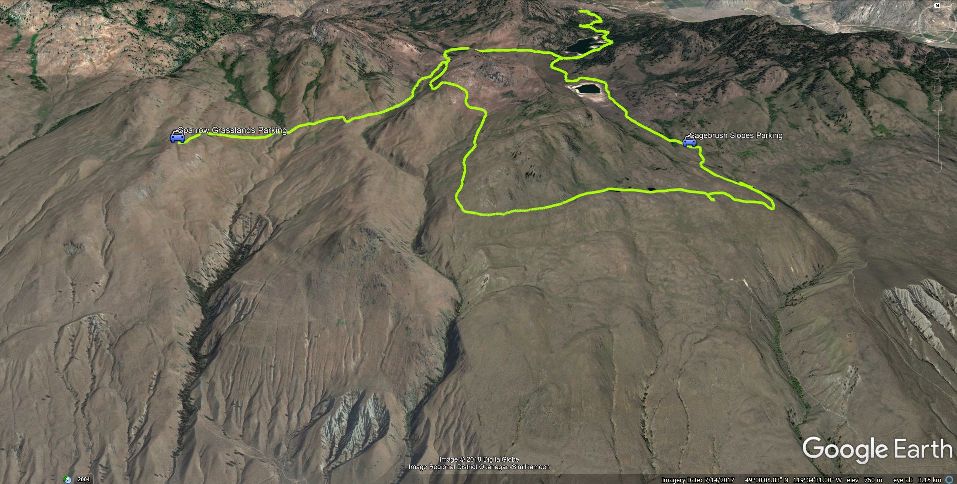
For this chapter, I've created Google Earth and generic GPS data files which provide guidance through a 17km. loop within the area.
The entire zone is sliced and diced with private, NGO and Crown lands. The area is officially laid out as two roads ending in separate parking lots, as you'll note if you download and view the aforementioned track files, available at SweetSingletrack.ca.
However, BC Parks and Nature Conservancy of Canada staff state that as long as we visit areas beyond the Sage & Sparrow parking lots on foot (ie; no bikes or horses) and stay on established trails, we are free to explore the zone. Most private property is delineated and signed.
The loop that I've described here is not part of the official NCC map though it connects the two parking areas via an old resource extraction road. Feel free to take this as a 17km. hike, or merely park at one of the official parking areas and stroll to a nearby lookoff point.
If you are visiting this area spring, summer or fall - be prepared for heat! That means bring loads of water, sunscreen, snacks and a good hat.
Major nod's to the Nature Conservancy of Canada's website; knowledge from which I've borrowed heavily in order to create this chapter.
Click the map atop this page to see an enlarged version.
Low: 784m | High: 939m | Length: 17k. loop| Water: Not Potable | Cell Access:Spotty
