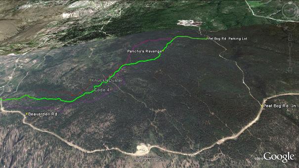
2009 and 2010 found 'Pancho', aka; 'Frank The Builder', spending many long solitary days in the forest above Penticton constructing his masterpiece: "Pancho's Revenge". This trail was created as a "Thank You" to all of the individuals in the community who helped FTB when he was injured and down during a previous riding season.
Lucky for all of you who enjoy seat of your pants riding styles, FTB gives back to his riding community twice as good as he gets!
Frank's masterpiece of fear features drop after drop, stunt after stunt, skinny after skinny of exhilaration! This is a black to double-black diamond ride; definitely not for the cross-country crowd, nor those without sufficient body armour.
In the few runs that I have taken down Pancho's Revenge, I've smacked myself silly and witnessed friends sporting the splatter of blood as well as multiple broken bones. I've also heard reports of events that unfolded within a group of riders the last time I was on it, including a cold-clocking of one of the valley's best DH riders. I wouldn't recommend that anyone attempt to ride Pancho's without full armour and a very keen sense of bike handling skills.
Take the time to stop and 'suss-out' every technical trail feature prior to attempting (or walking around) it...
Despite the grave warnings above, I can say that I very much enjoyed the thrill of Pancho's many skinny log rides and teeter totters, the Three Amigo's triple drop section and wild singletrack. Most of the adventures hidden within Pancho's are not very high off the ground, its just that the trail is oftentimes so isolated from a rescue road, that extraction of injured individuals ups the danger level of the trail.
In the map above (click to enlarge) I have highlighted Pancho's in green, with Knuckleduster faded into the background in red and Code 4 in purple. As you can see, Pancho's starts from the same location as the aforementioned trails, piercing through the middle of the two later in the descent, rejoining them at the trail's terminus.
Getting there This is pretty much a repeat of the instructions to access the Code4 and Knuckleduster trails. Beginning at the Peach in Penticton, drive up Winnipeg St. to Eckhardt Ave. Turn left on Eckhardt and drive to Government St. Turn right on Government St. and continue to Carmi Ave. Take a left onto Carmi and stay on it to the intersection with Beaverdell Rd., turn right on Beaverdell. Stay on Beaverdell to the cattle guard at the Garnet Fire interpretive site parking lot.
Continue along Beaverdell Rd. beyond the Garnet Fire interpretive site parking lot a further 4.5km. There you will see the Peat Bog Rd. join on your left, marked by large blocks of concrete. Hang a left off Beaverdell Rd and travel up the Peat Bog Rd. 2.1km. A small parking area will appear on your left. The Peat Bog Rd. continues north, and a pair of old logging paths rise into the forest to the west, just beyond the end of the parking lot (what might best be described as "roughly resembling a parking area...").
Climb up the main logging path off the end of the parking area for approximately .5km, where a singletrack trail will soon become visible, peeling off to the left. Do not turn left at the Google Earth signage and two-track trail along the way, that left-hand juncture represents the Carmi Recreational Trails, found elsewhere on this site.
Ride the singletrack trail or stick with the road; your call. Hang a left 250m later, when the road or trail that you are on meets the very next abandoned logging road.
Those who took the singletrack trail as far as the abandoned logging road will see a wooden technical trail feature before them; those who stuck with the road must turn left and travel 100m when their road meets another logging road. Both routes eventually place you are the same wooden technical trail feature. It represents the combined trail head of the Code4 and Knuckleduster trails (before they also split). Check out this large, zoomed-in map of the junction area.
Ignore this structure and it's entrance and head southwest down the abandoned logging road for a distance of 120m (that's a left for those who rode to this junction along the singletrack trail). There on your right, partially hidden near the mud-flat, is the not so obvious entrance of Pancho's Revenge.
The trail is extreme enough that F.T.B felt that it should remain as a route that only those very strongly inclined to find it's entrance should do so. I concur, and so have not gone out of my way to create an obvious entrance either.
If you are keen to find it; armour up!
Low: 1030m | High: 1475 | Length: 4.5km Loop | Water: None | Cell Access: Spotty
